Man, drones have changed my life—and my whole job, too. 🚁 I'm writing this at 2am in Tulsa, coffee in one hand, drone SD card in the other. Let me share how I stumbled and learned (the hard way, sometimes) to build a solid drone survey workflow for agriculture and infrastructure health monitoring. It's 2025 now, tech keeps moving, and if you're even thinking about drone surveying services (especially for farms or roads), maybe I can save you six months of mistakes.

My First Drone Jobs: Flying Blind and Loving/Hating It
Back in late 2023, I landed a gig through a Facebook group—someone wanted a crop health survey near Norman, OK. All I had was a DJI Phantom 4 Pro, barely used outside of crashing into my neighbor's tree (no joke, the guy's still mad about it).
So, I showed up, full of nerves. No plan, no workflow, just a pile of YouTube tutorials and a lot of hope. First thing I messed up: didn't set up ground control points. My "orthomosaic mapping" was so warped, the farmer thought I was pulling a prank. Weirdly, he still paid me. (Thank you, Jesse, wherever you are.)
Since then, I've done jobs for the Oklahoma Department of Transportation and a couple of big wheat farms outside Enid. Each gig taught me things that manuals never mention. Yeah, drone surveying services sound high-tech, but man, messy reality slaps you fast. 💥
Workflow: The Good, The Bad, The NDVI Green
Every job's different, right? Still, I built a kinda foolproof (I hope) workflow out of stubbornness and a stack of mistakes. Here's how I roll when I get an email asking for UAV photogrammetry, DEM and topographic analysis, or even wild 3D CAD modeling jobs.

Scoping & Compliance (No, You Can't Just Fly)
First off, check your area. RPAS regulatory compliance isn't just buzzwords. In Oklahoma, we operate under FAA Part 107—no shortcuts. One time in 2024, I forgot to get an airspace waiver near Tinker Air Force Base. The FAA wasn't amused. Lesson learned.
I now use AirMap and Aloft apps to check airspace and log all flights. Better safe than grounded (or fined, right?).
Planning and Sensors: Picking the Right Tools
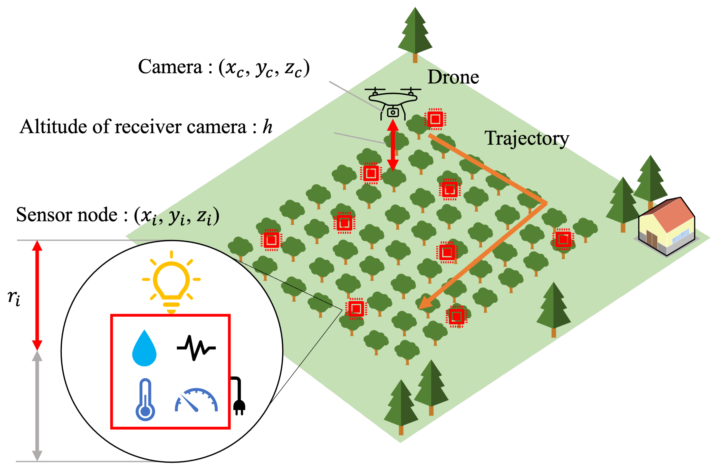
Cameras matter more than you think. For NDVI agricultural monitoring, I use a Parrot Sequoia sensor. For infrastructure, I stick with thermal inspection imaging on my DJI Mavic 3T.
Do yourself a favor and over-communicate with clients. I learned this with a bridge job for ODOT—they wanted volumetric site measurement, but didn't mention they also needed thermal data until I was packing up. Always ask.
Data Collection: It's Chaos, But It Works
My workflow for on-site:
- Lay out GCPs (I use Propeller Aeropoints—expensive, but they save you serious headaches)
- Double-check battery counts and SD cards (I forgot spares once… worst day ever)
- Pre-program routes in DJI Pilot or Pix4D Capture
- Pray the wind chills out (Oklahoma, man…)
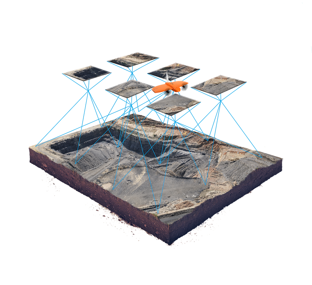
For orthomosaic mapping or DEM, I keep overlap at 75%/85% (front/side). For NDVI, same thing but check the sun angle. Clouds can f*%k everything up.

Post-Processing: Where the Magic/Hell Starts
I run raw data through Agisoft Metashape or Pix4D. (ArcGIS Online for GIS data delivery.) You'll go crazy waiting for renders, but in 2025, cloud processing at DroneDeploy saves my bacon—no joke, my laptop nearly melted using local software.
For topographic analysis, I build DEMs, check accuracy (against surveyed points), then export deliverables as GeoTIFFs and shapefiles. For 3D CAD modeling, Autodesk ReCap and Civil 3D connect pretty well with Pix4D outputs.
Table: My Go-To Drone Survey Tools (2025)
| Product/Brand | Best For | Price Range | My Rating (1-5) |
|---|---|---|---|
| DJI Phantom 4 Pro | General orthomosaic mapping | $1,000 - $1,500 | 4 |
| Parrot Sequoia | NDVI agriculture surveys | $3,000 | 5 |
| DJI Mavic 3T | Thermal inspection imaging | $4,200 | 5 |
| Propeller Aeropoints | Ground control points (GCPs) | $5,000 (set of 10) | 5 |
| Pix4D / Metashape | Processing / photogrammetry | $200/mo+, $3,499 | 5 |
| DroneDeploy Cloud | Cloud-based, time saver | $149/mo | 4 |
| ArcGIS Online | GIS data delivery+analysis | $100/mo+ | 5 |

Real Lessons - My Top Tips and Slip-Ups
Honestly, every job is different. Still, here's what I wish I'd known before I started: 🎯
- Always over-communicate job requirements.
(Clients change their mind. Every. Single. Time.) - Bring backup batteries, SD cards, and propellers.
(Forgot once… ended up sat in my truck, crying into a Big Gulp.) - Lay out your GCPs, even if you think "the site's flat."
(DEM accuracy sucks if you skip this.) - Monitor weather hourly.
(Oklahoma wind is a beast. I've lost two drones.) - Invest in good processing software.
(Cheap software = garbage output.) - Know your compliance rules (FAA, local city, clients).
(Or risk major fines and losing trust.) - Thermal data is magic for bridges and roofs.
(Seriously… reveals crazy stuff you don't see at all.) - Don't overpromise timelines.
(Cloud processing speeds it up, but debugging bad data ruins your day.) - Network with other surveyors.
(I joined ASPRS and the Oklahoma UAV Association. Amazing support.)
Fast Comparison: NDVI, Thermal, or Standard RGB?
| Use Case | Fastest? | Costliest? | Most Accurate? |
|---|---|---|---|
| NDVI Monitoring | No | Yes | Yes |
| Thermal Inspection | Yes | Yes | Sometimes |
| RGB Orthomosaic | Yes | No | Good |
- NDVI's slow but worth it for farmers
- Thermal's fast, but expensive
- Regular photos are quickest, but maybe less detail
What the Experts Say
According to an FAA advisory published in March 2025, "UAV photogrammetry now provides sub-inch accuracy levels when combined with verified GCPs and cloud processing software." (FAA)
Dr. Maya Patel at Oklahoma State University told the Tulsa Drone Summit in Jan 2025:
"The main challenge today isn't drone hardware—it's getting reliable, interpretable data out of diverse farm and infrastructure environments."
And, man, she's not wrong there.

FAQ: Real Answers from the Field
Q: How much does pro-level drone surveying cost in Oklahoma in 2025?
A: Honestly? Could be $1,200 to $5,000+ per job, depending on area and data deliverables.
Q: Can you skip FAA compliance for small jobs?
A: Don't risk it. Fines are nasty. Even for one-acre fields. Local cops sometimes check, too.
Q: NDVI: Is it that valuable for my farm?
A: For big fields, yeah—shows crop health better than the naked eye. But if you have five acres, maybe skip it.
Q: Is cloud processing always faster?
A: Usually… unless there's a big upload queue. I had one job sit for 10 hours during wheat season.
Q: 3D CAD outputs—are they really needed?
A: For bridge repair or earthwork, yes. For most farms? Nah. Overkill for soybeans.
My Reflection: Why I'll Keep Flying (and Failing and Flying…)
Look, I'm no superhero, and I still mess things up. But drone surveying services? They've changed my career and let me meet some wild clients (and cows). For me, the key's been learning fast and not getting discouraged by data errors or Oklahoma storms. I just want you to know—no workflow's bulletproof, but if you keep grinding and stay curious, your surveys (and clients) will only get better. 🚀
If you're thinking about jumping into UAV photogrammetry, NDVI ag monitoring, or 3D CAD modeling—don't wait for the "perfect" setup. Start, mess up, fix it… you'll get there. Maybe I'll see you at a job site somewhere in the Plains.